Location Briefing
Choice of Location – a Briefing
LOCATION OPTIONS
Ramsey Marina Limited has received various requests for the company to explain its choice of location on the South Beach. The other options that have been mentioned are:
- North beach (also outside the harbour) and opposite Mooragh Park.
- Revival of the concept in having the marina in front of West Quay, behind a sill like Peel and Douglas.
- The other in-harbour location in the arm of the harbour abutting the Mooragh Lake, as proposed by several people.
BASIC LOGIC OF THE CHOSEN LOCATION ON SOUTH BEACH
The concept is to have a 24/7 all-tide marina, which will attract vessels not only as a “sail to” destinations but also those transiting the Irish Sea in a north-south direction. The all-tide access is critical to these people, as with weather and tide in the Irish Sea, it is often not possible to arrive off Ramsey in the period when the tide is high enough to enter a tidal gated marina in the inner harbour.
Thus, in order to maximise the number of visitors to Ramsey and increase the foot fall in Ramsey shops, that 24/7 access is critical, and will thus create a thriving marine leisure tourism industry for the Island.
A marina outside the harbour also can provide inshore all-tide boating facilities that an inner harbour could never do. Hence why RML are proposing that there is a National Maritime Sports Centre within the marina development, so that all the Island residents – young or old, rich, or poor – can enjoy the delights of Ramsey Bay from the water, be it on paddleboards, kayaks, or windsurfing. This will provide a healthier lifestyle for Island residents. Without an outside marina, inshore boating will be restricted, as at present, to hardy individuals who are able to launch their vessels of a wave lashed beach.
The out of harbour marina would allow the lifeboat to be moored afloat, immediately ready for action, in the marina, and not have to be launched for every emergency call-out. Indeed, the RNLI wish to put a fast inshore lifeboat at the marina – so lifeboat cover would be greatly enhanced.
NORTH BEACH
As the prevailing winds in the winter do come from the NE, the entrance to such a marina would have to be in the SE corner, thus directly in front of the existing harbour entrance. DoI have informed RML that some 30,000 tonnes of sediment comes down the Sulby River each year. And in the Ramsey Bay, by a quirk of geography, the tidal current runs northwards for 20 hours in every 24 – normally it would be split equally between north flowing and south flowing. The combined result of these two key issues is that the sediment, upon leaving the harbour (between the two light houses), would be pushed straight into the marina – causing the need for endless maintenance dredging as has been the case in Peel and Douglas.
By using the South Beach, RML are benefiting from the protection of Maughold Head to protect against the SE waves, which, according to long term data, are the largest of all other wind directions. Such protection from SE wind and waves is critical to the design, but such protection would be significantly diminished on the North beach.
In addition, at certain times, a standing wave builds up in the existing harbour entrance. This is caused by a combination of a spate in the Sulby River, a spring ebb tide, and an easterly wind. That standing wave would make the entrance of a marina on North Beach dangerous at times.
An initial analysis shows that the littoral drift (ie the sand being deposited on the beach in the Ramsey area and which, through the tidal current and wave action, is pushed northwards to the Point of Ayre) is far greater to the north of the harbour than the south. Thus, a marina to the north of the harbour is likely to have a far greater impact on the erosion of the coastline north of Ramsey. It is important to note how little sand is banked up against the southern harbour entrance pier, which would appear to confirm this hypothesis.
As part of the intent of RML is to increase footfall in Ramsey shops, locating the marina some way from the town centre would mean that this would not be achieved. The Park Hotel might benefit but few other commercial premises would. Thus, a marina to the north of the harbour would tend to pull visitors away from the current shopping areas of the town.
But more recently, and after RML had concluded that South Beach was the best option, the DoI published their plans for the protection of the Queen’s Promenade from flooding and rising sea levels. RML have designed the breakwater and the reclaimed land to maximise the benefits that the marina can bring to the whole question of the Ramsey flood defences. In short, the breakwater will be designed to protect the Queen’s Promenade from wave action and the level of the reclaimed land will be set so as to safeguard roughly 65% of the length of the Queen’s Promenade from tidal surge and rising sea levels, thus obviating the need for the taxpayer to pick up the cost of these flood defences.
RML have prepared a complete briefing document on the whole question of the danger of flooding in Ramsey, and this is in the Appendix to this paper.
INNER HARBOUR LOCATIONS
The key commercial and financial aspect of these locations is that there is no available space (as there was at the time of the Dean and Dyball proposal) for there to be any commercial or residential development which would interest any potential private sector investor to pay for an inner harbour marina. There are two possible options a) in the main harbour incorporating the Sulby River or b) the old river spur going up to Mooragh Park.
Any inner harbour marina in either location would have to funded therefore by the tax payer. Given the current circumstances, this is unlikely to happen.
A marina, taking in West Quay, would require, like Peel and Douglas, a sill under the swing bridge. Such a sill could only open for 2 hours either side of high water and could not remain open as clearly the swing bridge in Ramsey is a key part of the town’s road system, and could not remain open for 4 hours per day. That would rule out the overwhelming bulk of the potential visitor traffic that would come into a 24/7 marina, and thus would not generate increased economic activity in the town.
For the option in front of West Quay, there is the additional question of how to stop the 30,000 tonnes of sediment building up behind the sill and merely repeating the debacle that has been seen in Peel.
If the location was in the spur leading up to Mooragh Park, as has been proposed recently in the social media, then it is inevitable that some dredging would be required, even for an “inside the harbour” location, and the risk is that some of the material will prove to be contaminated as in Peel. Even this is not the case, the material would have to be dumped at sea. And again, it provides none of the economic and social benefits that the external locations would bring.
Both inner harbour locations could only house around 100 vessels, as in Peel and Douglas.
RAMSEY SHIPYARD
With 400 boats in the RML marina, they would require significant repair and maintenance capacity which could only be provided in the existing shipyard. Such repair and maintenance work could provide jobs for between 100 – 150 direct and indirect jobs and enable a Centre of Excellence in Marine Engineering to be established in Ramsey. Such a facility would need many apprentices and so offer marine careers to those leaving school here on the Island. A very similar sized shipyard in the Isle of Wight employs some 120 skilled staff and around 20 apprenticeships.
With smaller in-harbour locations, the level of repair and maintenance work may not justify the development of the shipyard as would a 400-berth marina.
FISCAL BENEFITS
By attracting visitors to the Island, the Treasury will benefit through increased VAT (though shared with the UK) and, in creating so many jobs, through increased National Insurance and Income Tax. Indeed, RML have calculated that this could about to between £50m and £80m over the first 10 years of operation – something that inner harbour marinas could never hope to achieve.
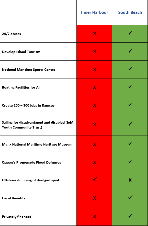
Tabulation of Location Issues
Briefing Paper on Flood Defences
1. The Current Situation
In June 2016, JBA Consulting undertook a detailed study of the flood risk of the Island. As can be seen from the table below (extracted from the JBA report), Ramsey stands out as the No 1 risk on the Island.
Here is an extract from that report:
Management & Action Area | J: Ramsey – J2: East and Coastal Ramsey | |||||||
Economic Damages | No. Properties at risk | Infratructure (m) | No. critical assets | No. vulnerable critical assets | Score now | Score 2060s | Revised score now | Revised score 2060s |
£113,217,561 | 1,038 | 229 including TT route | 17 | 21 | 202 | 404 | H | H |
Sources of risk
Tidal flood mapping suggests that a large portion of Ramsey would be vulnerable to flooding should a 1 in 200-year tidal flood (plus climate change allowing) occur. To the north of the river, properties on or close to the promenade between the sea and Mooragh Marina are most at risk. However, there is a greater flood risk to those areas to the south of the river. Any water overtopping the defence to the south of the Harbour is routed in north-westerly direction across low lying land on the south bank of the river. As this area is heavily populated a significant number of properties and residents would be at risk. Ramsey Harbour is at risk of still water level flooding during the 1 in 2-year event in present day conditions showing a very high risk of still water level flooding, highlighting the need for imminent defence improvements which are planned. Flood risk also from surface water flooding and fluvial flooding – Litney Stream and Sulby River towards the coast with a number of historic events including December 2015. Flood defences already in place helped protect some communities in Ramsey.
Historic risk
Frequent flooding over last century, substantial flooding 2015 including closure of mountain road connecting the north due to a landslip where traffic was diverted via the coastal road that was also flooded in parts. 1 in 10-year annual probability of flooding.
Source: National Strategy on Sea Defences, Flooding and Coastal Erosion: Evidence Report – Appendix B – Action Area and Outlier Analysis June 2016
A one in a ten-year storm could cause £100m worth of damage to private property.
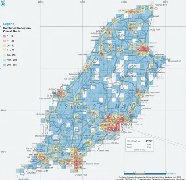
Below, the map of the Island illustrates how Ramsey represents the No 1 risk of flooding on the Island.
2. Causes of Flooding
There are two underlying causes of flooding; wave action and tidal surge. Having said that, rising sea levels constitute a long term risk of flooding, and an aspect of flood defences that needs serious consideration.
Figure 1 Flood Risk Assessment Map (Prepared by JBA)
In terms of wave action, three elements contribute to the height and frequency of waves:
- Wind strength
- Water depth, and
- Fetch
Fetch is defined as the horizontal distance over which wave generating winds blow.
The wave height data, gathered for the Airport Runway extension, gives a slightly different “view” from the wind rose. From the wind rose, one might deduce that the maximum wave heights are generated from the north-east (around 0600) whereas the wave buoy data used for the airport runway extension shows that the maximum wave heights are coming from nearer 1200 i.e. south east. See Figure 2.
Figure 2 Tabulation of Recorded Wave Heights
H1 |
H2 | Probability of exceeding H1 | WAVE DIRECTION ON DEGREES NORTH | ||||||||||||
|
|
| 55 | 65 | 75 | 85 | 95 | 105 | 115 | 125 | 135 | 145 | 155 | 165 | 175 |
|
|
| 65 | 75 | 85 | 95 | 105 | 115 | 125 | 135 | 145 | 155 | 165 | 175 | 185 |
|
|
|
|
|
|
|
|
|
|
|
|
|
|
|
|
0.00 | 0.50 | 73.41% |
| 314 | 3,498 | 2,025 | 932 | 774 | 631 | 681 | 8,641 | 13,985 | 9,989 | 1,167 |
|
0.50 | 1.00 | 30.77% |
|
| 6 | 1,202 | 1,702 | 1,363 | 1,329 | 1,228 | 5,614 | 6,217 | 118 |
|
|
1.00 | 1.50 | 12.00% |
|
|
| 76 | 599 | 838 | 1,076 | 1,135 | 3,837 | 29 |
|
|
|
1.50 | 2.00 | 4.41% |
|
|
| 4 | 131 | 373 | 460 | 810 | 1,219 |
|
|
|
|
2.00 | 2.50 | 1.41% |
|
|
|
| 23 | 120 | 203 | 350 | 319 |
|
|
|
|
2.50 | 3.00 | 0.40% |
|
|
|
| 2 | 34 | 49 | 163 | 55 |
|
|
|
|
3.00 | 3.50 | 0.09% |
|
|
|
|
| 8 | 15 | 38 | 4 |
|
|
|
|
3.50 | 4.00 | 0.03% |
|
|
|
|
|
| 10 | 11 |
|
|
|
|
|
4.00 | 4.50 | 0.01% |
|
|
|
|
|
|
| 4 |
|
|
|
|
|
4.50 | 5.00 | 0.00% |
|
|
|
|
|
| 2 |
|
|
|
|
|
|
|
|
|
|
|
|
|
|
|
|
|
|
|
|
|
|
Note: |
|
|
|
|
|
|
|
|
|
|
|
|
|
|
|
1. Hs is the significant wave height in metres |
|
|
|
|
|
|
|
|
|
|
|
| |||
2. Data recorded over 157,800 hours from April 1987 to March 2005 |
|
|
|
|
|
|
|
|
|
| |||||
3. Table shows number of hours over which each wave height is recorded |
|
|
|
|
|
|
|
|
| ||||||
Source@ HR Wallingford
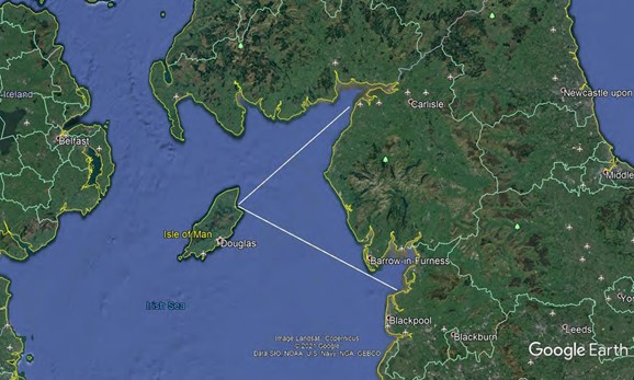
This can be shown graphically in Figure 3, with two long “fetches” – 75 nautical miles and 100 miles respectively:
Water depth is another constituent element in developing waves. Surfers will recognise that long shallow beaches tend to develop the “best” waves and tallest waves. Thus, generally the deeper the water the shallower and longer the waves. Having rotated the marina through 900, anti-clockwise, from the original layout, the breakwater will be in deeper water. Indeed, just beyond the proposed location of the breakwater there is much deeper water as the seabed shelves away.
Thus, the breakwater will not have to cope with wave heights seen against the sea wall, but those shown in Figure 2.
Figure 3 Wave Fetches
3. Protective Measures
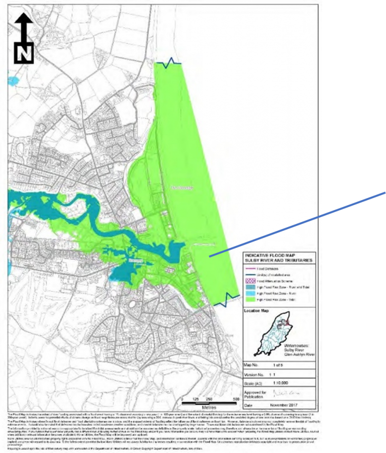
The marina can make a very significant contribution to flood prevention in Ramsey to the south of the harbour entrance, given the extent of the vulnerable areas as shown in Figure 4 below.
Figure 4 Ramsey Flood Map (from JBA report)
In terms of wave heights, RML are taking the view that Maughold Head will largely attenuate the waves coming from 1200 – per comments above – and that the breakwater will “catch” the waves before they reach the shallow water. Either way, it is imperative that no vessels are ever damaged by wave action over the top of the breakwater. In achieving that aim, it will naturally provide protection to the Queen’s Promenade and the buildings behind it.
In terms of tidal surge and rising sea levels, RML can raise the “finished grade level” (the height of the reclaimed land) to suit a 1 in 200 year forward projection for sea levels. RML is of the view that this will be between 1.5m and 2m above the road surface level of the Queen’s Promenade.
This will be computer modelled during the detailed engineering design phase. But it may be that it will have to be physically modelled at the world-renowned marine laboratory at HR Wallingford. You can see their work on https://www.hrwallingford.com/ .
Either way, the marina will make a very substantial contribution to Ramsey’s sea defences, th us avoiding significant costs of standalone sea defences.
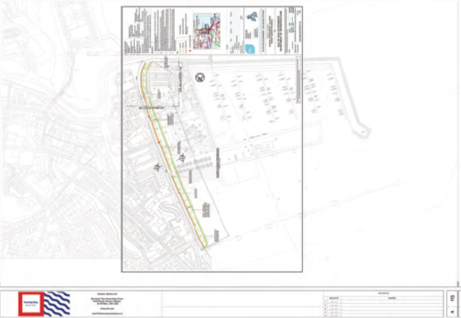
This is illustrated in the drawing overlay of the marina on the DoI proposed food defences in Figure 5 below:
Figure 5 Proposed JBA Flood Defences – Superimposed on Marina
In conclusion, the marina can avoid the need for a 7m high sea wall, and 20m wide concrete apron over the beach on South Bay. Because without the marina, that is what is proposed.